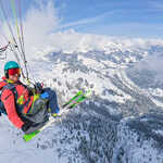
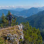
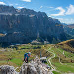
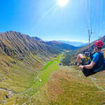
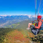
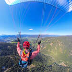
Blog Posts in Category: Mountaineering

Vorderes Sonnwendjoch and Rofanspitze

With a lovely forecast Becky and I decided to make the best use of our winter ski passes and use them to head up the Rofanbahn on the last weekend of validity. Unfortunately on the drive there it became clear that the weather was not as good as it was forecast. We decided to do a circuit from the Vorderes Sonnwendjoch, Sagzahn and Rofanspitze, and I planned to fly off from the Rofanspitze with my hike&fly gear. As we got to the top of the lift we emerged from the cloud to be treated to a wonderful view of the Karwendel and shortly after the Tuxer Alpen. We had hoped that we would stay out of the cloud as we were above it, but unfortunately this was not going to be the case and as we started the descent to the Schermsteinalm we descended back into the cloud. As we approached the summit of the Vorderes Sonnwendjoch we briefly left the cloud, which allowed us to enjoy the views before it decided that it would make an unwelcome reappearance. From Sagzahn we again had not much of a view, so. Read the full article…

Heuberg

Despite a dodgy forecast for the day we were keen to do something, after waking up it became clear that the best weather of the day was going to be later on, so we decided to head for a short evening walk up Heuberg. The majority of the ascent was in the woods, so the cloud made little difference to the views. However, unfortunately as we emerged onto the ridge we also ascended into the cloud, which meant that we were unfortunately lacking a view. As we were waiting on the summit the clouds started to lift and give is fleeting glimpses of the views which one could normally expect from this peak. We enjoyed some food on the summit before starting the descent, aiming for an alm for a drink and some Kaiserschmarrn. The descent was very muddy which made it slow going as it was very slippery, however we made it to the alm in good time to have a drink prior to its closing time.

Wösterhorn (Wösterkopf) Skitour

After munch debate about what we were going todo, on our second day in the Bregenzerwald we decided to head to the beautiful Lechtal with the objective as the Wösterhorn/Wösterkopf, which was an objectively very easy skitour, but it started high and we expected it to have fantastic views. The tour started easily out of the car park along a prepared piste which we followed for a few kilometers before branching off and heading off the beaten track. The initial ascent was wonderful with a beautifully made skin track which gently worked its way up the mountain with no need for any kick turns, as we climbed the terrain progressively became steeper and soon we were firmly in easy kick turn territory up to the Wöstersattel. The top of the ascent to the Wöstersattel became very cold as it was in the shade with a wind blowing down the slope, so it was great to emerge at the Wöstersattel and into the sun. From here the views up the Lechtal were absolutely beautiful and we could see north into Germany and the persistent inversion. From the Wöstersattel the ascent to. Read the full article…

Zafernhorn

Following fresh snow in the week and with a sunny weekend forecast, Eric and I decided to head to the Vorarlberg for a weekend of ski touring. As we had both had busy weeks with business travel and long days, we set off from Munich relatively late, leaving at around 8am. This only left time for a relatively short ski tour and after some planning we decided to head to the Zafernhorn in the Bregenzerwald. The tour started easily up a Forststraße, from which we emerged with stunning views at a beautifully located hut. From there we continued up towards the summit with no particular difficulties, there was one steeper section where we had to remove our skis and walk up, but otherwise it was fairly straight forwards. When we set off there was no sign of an inversion, but as time progressed it moved slowly up the valley and provided a wonderful view. When we got to the summit there were a number of other teams there, enjoying lunch, but we just quickly took some photos and headed back down, not wanting the snow to become any wetter. After. Read the full article…

Wetterkreuzkogel Ski Tour

After not getting to an actual summit yesterday due to the quantity of fresh snow no the ridge, I wanted to ensure that Katherine actually ski toured to her first proper summit today. I decided that with the snow conditions at the moment our best bet was to head back to the Wetterkreuzkogel, which I first did with Adam on a week long ski touring trip in 2019. We decided to go for an early start as some of the forecasts suggested that bad weather would come in around lunchtime, and it meant that the route would be quieter. It was another very cold morning, my car said -15 degrees as we were driving to the car park, and I think it was about -13 degrees where we parked. We took the phrase “be bold, start cold” to heart and were absolutely frozen as we left the car, but soon our cores warmed up as we climbed abruptly from the car up the twisty track in the forest, and eventually my fingers even warmed up. We emerged from the woods as the high cloud in the sky was being lit. Read the full article…

Kreuzjoch Ski Touring

With a forecast for overnight snow, followed by sunshine at some point in the day, I decided to take Katherine on her first ski tour. As we left Munch in the morning, I knew we were heading to Kühtai, but had a number of different options in my mind based on the updated weather and avalanche forecasts. As we were driving towards Kühtai, it is safe to say that it was not looking positive with extensive cloud above us, although that was not too much of a surprise as we knew it was improving throughout the day. What was surprising was at how quickly it improved as we drove up the valley through Kühtai and drove though a temperature inversion. As we arrived in Kühtai to hire skis for Katherine the mountains were basking in sunshine, although it was very cold, I think the car read -8 degrees. I elected to head to Mitterzeigerkogel, as I knew most of the route from my previous tour in Kühtai, and I knew it was an easy tour up to the Kreuzjoch. We made great time on the ascent, despite it being Katherine’s. Read the full article…

2024 in 100 Photos

It seems hard to believe that another year has passed by, but having just had another overindulgent Christmas and new year it is somehow already time to summarise the year in another 100 photos. It was a very busy year with both free time activities and work with many more business trips for me than usual. Winter The year started off with the ski season, we did a lot of alpine skiing and certainly made the most of our Tirol cards, I think I did around 25 days overall! Becky’s skiing has continued to improve and this led us todo our first ski tour on the Kleiner Gamsstein. Unfortunately the snow over the winter was difficult for ski touring, especially for beginners so there was limited ski touring for both Becky and me. I managed one ski mountaineering weekend, but we suffered with terrible snow conditions as well as weather. It was nonetheless enjoyable to spend a weekend high in the mountains. Spring It soon turned to spring, which was unfortunately a bit of a washout along with the start of the summer. This resulted in us not spending that. Read the full article…

Bleispitze Hike and Fly

I thought that when I returned from India and then the UK the mountains would have their winter coat, unfortunately they do not yet, so I decided to make the most of the sunny still conditions and headed to climb the Bleispitze above Bichlbach and fly back down. As I could travel there for free using the Deutschland ticket, I elected to take the train despite it taking significantly longer than driving. I was surprised at the amount of snow in the valley at Bichlbach and as I headed up the valley towards Berwang, but these valleys hardly get any sun at this time of year so it hadn’t melted despite the sun over the past few days. I had planned on heading up via a much less well trodden path which involved heading steeply up to join a ridge which runs up to the summit. I could find no trace of a path as I walked past the turn off, and when I used gps to work out where it should be, it appeared to traverse across steep grassy slopes which were covered in wet snow. Due to this. Read the full article…