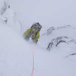
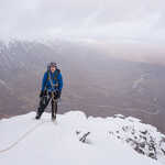
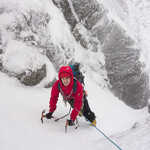
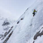
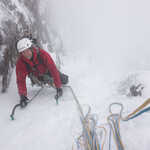
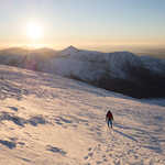
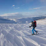
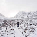
Blog Posts in Category: Locations

North East Ridge of Stob Ban

The weather forecast on Monday was pretty good and suggested that the lower summits should be free of cloud and that there may even be some sunny spells so most of our group were heading to do Stob Ban via the East Ridge before heading along the ridge to Mullach nan Coirean, a walk which I did last new year in hill fog and gale force winds. I was planning on heading to Aonach Mor again with Jon to do some ice climbing, however after the fail of the previous day this time we had a backup plan which was the East Ridge of the North Buttress of Stob Ban, a grade II/III route depending on how closely you followed the ridge. Again we got to the gondola station to find them on hold due to wind and after a coin toss we waited until 9am when they were reviewing their status. This turned out to be pointless as at 9am they reviewed and were shut until midday so we changed to our backup plan. As we were not optimistic about them opening we re-packed our bags removing the ice. Read the full article…

Remote Winter Walking up Fraoch Bheinn

For the first day of our Scotland trip no one wanted to have a long day so I was going to go ice climbing on Aonach Mor with Stephen and Simon due to being able to get ski lifts up to circa 900m while the others were going to do a grade I gully on the west face of Aonach Mor, however this plan was changed as when we arrived at the gondola station at 9am the lift was on hold due to the wind being much stronger than forecast.Due to not wanting to waste the day we headed back to where we were staying to head NW where there was supposed to be better weather, after a quick look at the map we decided to head up Fraoch Bheinn via the South Ridge and Descend down the North. The drive down the side of Loch Arkaig was fantastic but much longer than expected and I have never driven on a road like it, however eventually we did arrive at the end and start walking. We arrived at the snow line fairly quickly however all the way up the south. Read the full article…

Winter Climbing On Snowdon

With the recent cold snap there has been a lot of talk around down south about the beacons coming into winter condition. As I had holiday which I had to take before Christmas I took a punt at the start of the week and booked Thursday off as it was due to be the last cold day before the thaw. However when Wednesday night came reports were coming from locals who had been to scout out the conditions on Wednesday and it turned out that nothing was in good nick so rather than spending the day at home we headed up to Snowdonia for the day, this involved setting my alarm for 2:15! We arrived at Pen-y-Pass car park at around 7 with a beautiful starlit sky and started walking towards Trinity face along the miners track. It was a beautiful walk in as dawn broke and then as we were walking around the lakes the sunrise started with a beautiful horizon and the top of Snowdon being kissed by the sun, it definitely reminded me of alpine days. Once we got to Llyn Glaslyn we noticed the waterfall up. Read the full article…

A Week in Snowdonia

I have just got back from a fantastic week spent camping in Snowdonia National Park in North Wales. Heading up for a weeks camping in North Wales in October I was expecting the week to be full of wet weather and hill fog, I was very wrong with only one day being a wash out and only one day was spent with an annoying amount of time in hill fog. For the first two days I met up with the expedition society from Exeter Uni which I was a member of last year and who were in Snowdonia with 15 people for some scrambling. Despite arriving in the rain we awoke on the first morning to a fantastic sunrise over Tryfan and its North Ridge, one of the most famous scrambling routes in the UK for obvious reasons. Despite having done the scramble up Tryfan’s North Ridge about 7 times in the past 3 years every time I climb it I manage to take a slightly different route which keeps it interesting, and when the weather is good the views are spectacular and I don’t think I will ever get. Read the full article…

Jegihorn Via Ferrata

After three high mountain days we were all beginning to need a rest day but as there was only one more day of good weather forecast we decided to carry on and head up to the Jegihorn via ferrata, it is a rather special via ferrata as it climbs up to a summit of 3206m with stunning views of the Saastal mountain ranges on the ascent. The walk into the start of the via ferrata at 9am was unbelievably hot due to being sheltered from the breeze though thankfully once we arrived at the start of the route there was a breeze which reduced the temperature to a great level. The route was unlike most other via ferratas I have done as for the most part there was just a cable for protection while the climbing was scrambling on the rock and pulling on the cable which I have only encountered once before on a very hard via ferrata in Austria last year. This type of via ferrata is more fun, though it also creates more exposure due to it being harder scrambling than following metal rungs up the mountain,. Read the full article…

Weissmies SSE/WNW traverse

For me this was the aim of the trip, it is what I wanted to do if many different factors came into play and while I really wanted it to happen I was unsure if it would. Thankfully everything went perfectly and having made a choice on days based on the weather forecast we committed to the route and I am so glad we did as it was just such a fantastic two days as it had everything that an alpine route should have (apart from bad food at the hut!) as it had a beautiful sunrise, an amazing cloud inversion, a snow slope, a rock ridge, a sharp snow arête, great descent, glacier crossing and a different descent to ascent. We approached the hut via the Furggstalden ‘via ferrata’ to add a bit more interest to the long ascent to the hut (almost 1000m) in the strong afternoon sunlight, it was a lovely ascent just very hot and I struggled with a very painful back due to carrying the rope and have now decided that my bag isn’t great at carrying large loads for extended periods of time. I was hugely. Read the full article…

Allalinhorn

After a very successful first week in the French Alps we headed out to the Saastal area of the Valais in Switzerland. We had a very rainy drive over and put the tent up in showers but the forecast for the rest of the week was positive though it turned out to be a lot better than expected for alpine stuff due to being more concerned about the morning than afternoon. I was leading three of my friends as none of them had been to the alps before, walked on a rope and one of them hadn’t even worn crampons. Due to this we started on an easy first peak called the Allalinhorn where it’s possible to get a cable car and underground railway up to 3454m which meant that with 575m of ascent it was possible to get to the summit of a 4027m peak which is fairly impressive! The other reason for doing this peak was for more acclimatisation purposes before we attempted the Weissmies later in the week. On leaving the underground railway we were greeted by very hot weather so we started walking in tshirts on very soft snow, which. Read the full article…

Aiguille de la Grande Sassiere

Towards the end of my first week in the French Alps I headed up the Aiguille de la Grande Sassiere (3751m) on my own which made it my first solo alpine summit, this was due to having left the hut to hut walk early due to a member of the group injuring their knee. Choices for the route I was going to do was limited as it had to be a single day route, had to not involve a glacier crossing and also had to not involve any technical climbing. This lead me to an obvious choice of the Aiguille de la Grande Sassiere as it is a simple rock ridge, followed by a snow ridge, snow slope and rock ascent to the summit. I set off from Le Saut at 4am in the pitch black and managed to find the small path up through the meadows which was a brutal ascent up to the start of the ridge, but thankfully as it was 4am there was no sun and it was very cold, this combined with not actually being able to see how far up I had to go. Read the full article…